Category Archives: Lesser Known India

Home / Archive by category "Lesser Known India" ()

Cherrapunji Sightseeing

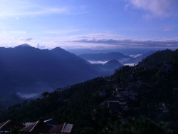
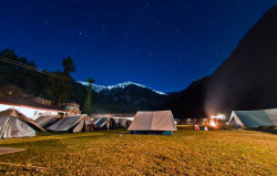
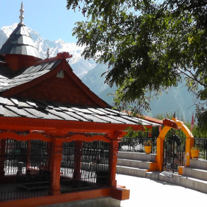
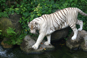
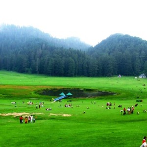
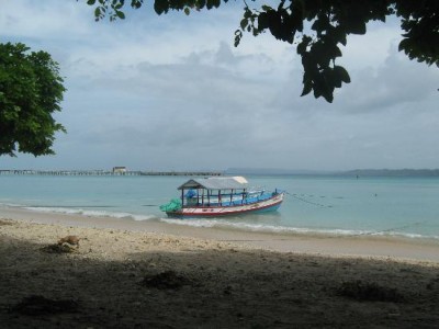
Cherrapunji : Cherrapunji or Sohra as it is known by the locals is one of the main reasons Meghalaya is known all over the world. Once the wettest land on Earth, Cherrapunji is mesmerising. The undulating hills, the many waterfalls, the panoramic view of the Bangladesh plains and a glimpse to local tribal lifestyle make a visit to Cherrapunji memorable.   Glimpse Of East
06 NIGHT / 07 DAYS
2N Guwahati – 2N Kaziranga – 2N Shillong
Standard : INR 25,300
 Eco Park #
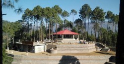
Eco Park
The Eco Park has been created in the plateaus by the Meghalaya government. At this Eco Park, tourists can see beautiful orchids growing in abundance in green house, which are given by Shillong Agri-Horticultural Society. In addition, tourists visiting this eco park can enjoy views of beautiful Sylhet Plains of Bangladesh.
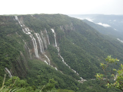
#Mawsmai Fall
Mawsmai Falls, the fourth highest waterfall in India, is located at a distance of few kilometres from Cherrapunjee. Located at a distance of 2 km from the monument of David Scott at Sohra, the height of this waterfall is 1,035 ft. This waterfall is also famous by the name of Nohsngithiang Falls.
 mas-fall
 Mawkdok Dympep Valley View #
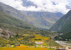
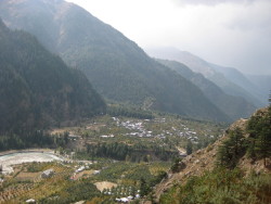
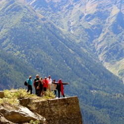
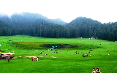
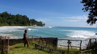
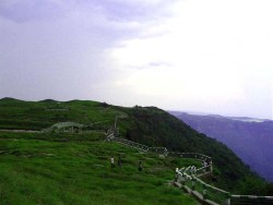
Mawkdok Dympep Valley View
The Mawkdok Dympep Valley View, located at the very start of Sohra tourist circuit, is one of the most prominent attractions of the place. The forest department has made a view-point at this valley from where tourists can enjoy and appreciate the natural beauty of the valley.
#Thangkharang Park
Thangkharang Park, located at a distance of 12 km from Cherrapunjee, is another popular attraction of the destination. This park is under the vigilance of State Forest Department Control. Inside the park, visitors can see the Khoh Ramhah rock, which in its shape is like an upside down basket.
 Thangkharang Park
Nohkalikai fall  #
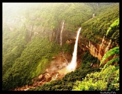
Nohkalikai Falls
Nohkalikai Falls was one of the taller waterfalls in India. It made a dramatic free leap from a fairly well-forested drainage into a rocky base accompanied by a pretty blue pool. While Julie and I noticed that most of the waterfalls in the Cherrapunjee area had really lost their luster outside of the monsoon season, this waterfall seemed to have maintaind its perforance.I suspect that the relatively healthy drainage upstream of the falls was largely due to the moisture-retaining foliage that remained forested and untouched (though this might be threatened based on what we saw, which we’ll get into later)In fact, we even saw a pair of light flowing companion waterfalls making similar dramatic leaps off the escarpment. I’d imagine in wetter times, there could have been many more companion waterfalls flanking the main one.

Cherrapunji Sightseeing

Loading image... Loading image...

Palakkad Sightseeing

Palakkad : Palakkad is rightfully known as the Gateway of Kerala, giving the rest of India access to the State. Its other name is Palghat was contributed by British Raj. Palakkad is a land of palm trees and paddy fields. It’s known to be rich in flora and fauna.Palakkad is prime among Kerala’s most picturesque districts, thanks to its distinctive palmyra trees and extensive green paddy fields. The abundant forest wealth,dams,wild life sanctuaries,rivers,rare birds and animals, historical monuments,traditional ayurvedic treatment centres have given Palakkad an exquisite and outstanding touch.
Palakkad Fort

#Palakkad Fort
Palakkad Fort, also known as Tipu’s Fort among the natives, was constructed by Haider Ali in 1766. This old granite fort located near the centre of Palakkad Town is presently operational as a Taluk Office. The fort is spread over an area of around 60702.84 sq m and is known for its architecture that displays the workmanship of French engineers.
The large ground between the fort and the Palakkad Town Hall, popularly known as the Kota Maidanam, served as a stable for elephants and horses of Tipu Sultan’s army. The garden is presently used for hosting exhibitions, public meetings, competitions and cricket matches. The Rappadi or the open air auditorium in the fort has been preserved by the Archaeological Survey of India (ASI).
This square shaped fort is supported by walls and bastions that are located in the four corners. Earlier a draw bridge was used as the main entrance for the fort. This draw bridge has now been replaced by a strong and permanent bridge. The fort also houses a Hanuman Temple, a sub-jail and a martyr’s column. The Jainmedu Temple, Kumarapuram Temple, Manapullivaku and Vadakkanthara Temple lie in the vicinity of the fort.

#Silent Valley National Park
Silent Valley National Park is situated in the Kundali Hills, along the Western Ghats. This park is surrounded by the Nilgiri Forests in the north and Nilambur Forests in the south. The Palghat Forests and Attappadi Reserve Forests are located on the western and eastern side of the park, respectively.Environmentalists protested on a wide scale and it led to the re-notification of the Silent Valley. Afterwards, it was raised to the status of a National Park in 1984. Later in 1986, the park was included in the Nilgiri Biosphere Reserve as its core area.
This national park is home to 34 species of mammals, more than 150 species of birds and about 200 species of butterflies. Around 1000 species of flowering plants are found in the park, out of which, about 110 species belong to the family of orchids. Over 400 species of moths and 128 species of beetles can be spotted in the forest area.

 Silent valley national park
 GRS-Fantasy-Park-Mysore

#Fantansy Park
Fantasy Park, located around 6 km away from Palakkad, is the first amusement park of Kerala. Spread over an area of around 60702.84 sq m, the park is divided into three main areas namely the dry park, the wet park and the planetarium. Situated in the vicinity of Malampuzha, the park serves as an ideal weekend getaway and picnic spot.

The Baby Train Ride, Battery Car Ride and Water Kiddy Ride are some of the rides popular among children. The Oriental Express Train, Go Cart and Pirate Boat can be enjoyed by the whole family. The wet park has the Wave Pool, Malampuzha Falls and Water Blasters rides.The park has recently introduced a digital planetarium as an additional attraction. The main objective behind introduction of this planetarium is to encourage children to think and discuss about astronomy. This planetarium is based on concepts related to space, space exploration and space technology.

#Jain Temple
The temple is segmented into four divisions, out of which the first division has the idol of Chandranthan. The deities of Vijayalakshmi and Jwala Mohini are enshrined in the second division and the idol of Rishabha Nathan is kept in the third chamber of the shrine. Parshvanath and Padmavathi idols are enshrined in the fourth segment of this temple. It is believed that the main altar of the temple was once home to a community of 400 Jain families.Kumaran Asan, a popular poet, wrote a poem Veena Poovu or the Fallen Flower, at the site. The Thiruvegappura Sankaranarayana Temple lies in the vicinity of the Jain Temple and is believed to have been constructed around the 14th century.
 Jain temple
 Kalpathy temple

#Kalpathy Temple
Kalpathy Temple, also known as the Kalpathy Viswanatha Swamy Shrine, is considered as the oldest existing Shiva temple in the Palakkad region. The annual Chariot Festival and a gala event that lasts for seven days attract many to the temple. The shrine was constructed by Kombi Achan, who was the King of Palakkad in 1425. Influenced by the Vedic Tamil Brahmin culture, the temple organises an annual Kalpathy Car Festival. The last three days of the car festival feature decorated temple chariots that are drawn through the streets of Palakkad. The Tamil Brahmin villages, now declared as World Heritage Sites, are frequented by tourists.

#Kanjirapuzha
Kanjirapuzha is a small town near Palakkad and is renowned for the dam that has been constructed across the nearby River Siruvani. The huge reservoir of the dam is a popular picnic spot.

 Kanjirapuzha Dam

Palakkad Sightseeing

Loading image... Loading image... Loading image... Loading image...

Keylong Sightseeing

Keylong : Keylong, also known as Kyelong or Kyelang, is the district headquarters of Lahaul and Spiti district of the state of Himachal Pradesh. This place is a fancy land of monasteries and Buddhism. Keylong is at an altitude of 3440metres on the Manali – Leh Highway. The place is cut off from the rest of the world as heavy snowfalls in the Rohtang pass, cuts out all road transport from the end of October to mid-May.
 The Highlands of Himachal
07 NIGHT / 08 DAYS
1N Mandi – 1N Manali – Rohatang Pass
2N Keylong – 2N Manali – 1N Chandigarh
Standard : INR 27,900
 Manali – Laddakh – Kashmir ( laddakh Road Trip )
10 NIGHT / 11 DAYS
1N Manali – 1N Sarchu – 4N Leh
1N Pangong – 1N Nubra – 1N Kargil – 1N Srinagar
Standard : INR 55,900
 khardang-monastery-keylong

#The Khardang Monastery
The Khardang Monastery or Khardang Gompa reflects the traditional culture and art of the region. Located at an altitude of 3500m, the monastery gives a picturesque view of the natural surrounding region. The building also has a library where one can find Buddhist literature, as well as Kangyur and Tangyur scriptures. Thankas and musical instruments like drums, horns as well as huge statues of the Lord Buddha are considered as the main attractions of the monastery.

#Shashur Gompa monastery
Shashur Gompa monastery is dedicated to a Zanskari Lama. Chortens, bells, conventional paintings and flags make the monastery appear even more beautiful. Devil dance is performed by the colorfully dressed monks during the month of June-July.
Shashur Gompa monastery
 tayul-monestary2 #Tayul monastery
Tayul monastery namely Tayul Gompa is assumed as the oldest monastery in the Northern region. The monastery is standing tall in the midst the mighty mountains. Interesting fables are associated behind the founding of the monastery. Once, Lama Serzang Rinchen of Khan Region in Tibet spotted this monastery when he was walking on and around the sacred Drilburi Peak. While walking on the peak, he spotted a small glade in the juniper forest. He showed the same to his pilgrimages, later he concluded that the place is an auspicious site to build a monastery and decided to name it as ‘Tayul’ which in Tibetan language means chosen place. Built in 17th century, the monastery is home to the Drugpa or Red Hat Sect of Buddhist monks.
#Guru Ghantal Monastery
Guru Ghantal Monastery. The monastery, also known by the name of the Trilokinath Temple, was founded by Guru Padmasambhava. The monastery is associated with the Drukpa order and is made of wood. Within, an image of ‘Boddhisatva Avalokiteshwara’ dominates. The white marble head of the monastery was installed by Padmasambhava himself, however it is now kept in safe custody so that it is not stolen away. Also, to be seen in this monastery are idols of Guru Padma Sambhava, Brijeshwari Devi and several other lamas.
Strange, but it is a fact that the monastery houses a black stone image of Hindu goddess Kali in its innermost chamber. This strengthens the belief that before being converted into a Buddhist religious place the monastery was a temple.
 Guru Ghantal Monastery
 trilok nath temple #Triloknath Temple
This is holy shrine is revered equally by Hindus and the Buddhists. Hindus consider Triloknath  deity as ‘Lard Shiva’  while the Buddhists consider the deity as ‘ Arya Avalokiteshwar ‘ Tibetan language speaking people called  him as ‘Garja Fagspa‘.This holy  shrine is so important that is it is considered as most scarred pilgrim thirth  next only to  kailash and  Mansarover . The uniqueness of   the temple lies in the fact that it  is the only temple in the whole world
where both Hindu and Buddhists  pay their reverence to the same deity . The temple is situated in the panoramic Chandra Bhaga valley to the western Himalayas . It is highly spiritual place where one gets the  spiritual  blessing of the lord of three universes i.e. Shri Triloknath jee by visit having this Darshan and offering ones prayers.

Keylong Sightseeing

Loading image... Loading image... Loading image... Loading image...

Barog Sightseeing

Barog : Barog is a small hill station in Solan district in the Indian state of Himachal Pradesh.   Lesser Traveled Himalayas
05 NIGHT / 06 DAYS
01 N Barog – 02 N Naldhera
01 N Shimla – 01 N Chail
Standard : INR 15,500
 Choor Chandni Peak

#Choor Chandni Peak
Choor Chandni Peak, having an elevation of 3,650 m above the sea level, is one of the most famous tourist attractions of Barog. The peak is situated at a height of 3,650 m above the sea level and is surrounded by pine trees. It is also known as the Choordhar Mountains as it gives an impression of various silver bangles sliding down the slope of the mountain on moonlit nights. A trek to the slope of the mountain will lead to the peak.

#Suketi Fossil Park
Suketi Fossil Park, which is situated on the banks of the Markanda River, is one of the most famous attractions of Barog. It was the first park in Asia to have been developed at the exact site where the actual fossils were found.The park has soft sandstone and clay rocks and is situated on the upper and middle Siwaliks. The park is famous for its life-size fibreglass model of the pre-historic animals whose fossil and skeletons were discovered at the site.
suketi_fosil_park
 karol tibba #Karol Tibba
Karol Tibba is a famous picnic spot, located in the Solan District, a few kilometres away from Barog. It is a strong belief that the Pandavas had taken shelter in this place, during their exile. This place is visited by a number of nature lovers and trekkers round the year.
#Dolanji Bon Monastery
Dolanji Bon Monastery, located at a distance of 5 km from Barog, on the Narag-Sarahan road, is also known as the Yungdrung Bon Monastery. It is run by the Yungdrung Bon Monastic Centre. The monastery was founded by Abbot Lungtog Tenpai Nyima and was constructed in 1969.
 Dolanji+Bon+Monastery
 barog_camping_ground #Barog Camping Ground
Barog Camping Ground is a registered camping site, which allows tourists to pitch up their own tents. This place is surrounded by pine trees and provides a beautiful view of the Choor Chandni Mountains and the Solan Valley.This site also provides different facilities to the travellers like bonfires, lodging, telephones, bathrooms, food, electricity, dance floors and natural trekking trails.

Barog Sightseeing

Loading image... Loading image... Loading image... Loading image...

Sangla Sightseeing

Sangla : Sangla is a city in the Baspa Valley, also referred to as the Sangla valley, in the Kinnaur District of Himachal Pradesh, India, close to the Tibetan border.

 Sangla Valley Tour
09 NIGHT / 08 DAYS
1N – Barog – 1N Rampur
2N Sangla – 2N Kalpa – 1N Fagu
Deluxe : INR 31,900
 chitkul-sangla3

#Chitkul
Chitkul is the last inhabited village situated near Indo-Tibet border at a distance of 20 km from Sangla. This village lies on the right bank of River Baspa. The most popular attraction of this village is the temple of local goddess ‘Chitkul Maathi’ also known as ‘Mata Devi’. People of the entire Kinnaur District come to worship at this temple. Chitkul also experiences heavy snowfall during winters, due to which it also becomes completely un-inhabited.

#Baspa River
The Baspa River is a fast flowing river that passes though the hills of Sangla. The surroundings of Baspa River provide an opportunity to view timely rainbows and brown trout. It is also an angler’s paradise for being home to a vast variety of fishes. Crossing this river is also quite an attraction amongst the visitors as this process involves ride in a basket along the way. Its surrounding areas also stand appropriate for campers and trekkers.
baspa river
 kamru-fort1 #Kamru Fort
The Kamru Fort is situated at an altitude of 2600 m above the sea level at 229 km from Shimla and 2 km from the Sangla Valley. It is located in the picturesque location of the Sangla Valley and is entered through a series of gates. At the main gate of this fort is a large image of Lord Buddha that welcomes you. There is also a wooden balcony at the top of this fort along with an idol of Kamakhya Devi installed in its third floor.This idol of Kamakhya Devi is said to have been brought from Guwahati. There is also a Badrinath Temple situated within the premises of this Kamru Fort that dates back to the 15th century. There is also a popular fair held in the place to honour the main deity of the temple. During this fair, the idol of the temple is taken to Gangotri, which is the origin of River Ganges.
#Bering Nag Temple
The Bering Nag Temple is another popular nearby temple and religious sightseeing destination of Sangla. This temple is dedicated to God Jagas. Its most popular feature is the Fulaich Fair, held here every year between the months of August and September.
 bering nag temple
 buddhist-monastery-sangla2 #Buddhist Monastery
There is also a fine Buddhist Monastery situated near Sangla. This monastery lies near the Reckong Peo in Brelengi due to which it is also known as Brelengi Gompa. This monastery displays modern Buddhist edifice. It was constructed by the Mahabodhi Society in 1992 for facilitating the Dalai Lama to perform the Kalachakra ceremony. Near to this monastery is a 10 m statue of standing Buddha, visible from a considerable distance.
#Sangla Meadows
The Sangla Meadows also known as Sangla Kanda is another natural sightseeing attraction in Sangla. This place is completely covered in greenery and surrounded by snow capped mountain ranges of the Himalayas. It also forms a perfect site to see the Kinner Kailash in an 180o view. This place will also provide a view of the local huts of Himachal along with the customs and lifestyle of its local people.
sangla valley 2 sarahan-meadow
 tibetan-wood-carving-center-sangla1 #Tibetan Wood Carving Centre
The Tibetan Wood Carving Centre is one of the most popular sightseeing destinations of Sangla. It is situated near the Saffron Farm in the outskirts of Sangla. Its main attraction are the items made out of wood carvings in Tibetan style. These items are present here for both display and sale purposes.

Sangla Sightseeing

Loading image... Loading image... Loading image... Loading image...

Kalpa Sightseeing

Kalpa – Kalpa is one of the most beautiful tourist attractions in Himachal Pradesh. Located at an elevation of around 2,758 meters above sea level, Kalpa is home to the wonderful Kinner-Kailash ranges amid picturesque Himalayan hills and serene valleys. Kalpa with its spiritual quotient and lovely natural landscape offers the best relaxation options for tourists and travelers away from the hustle and bustle of busy city life. From the rugged mountains to the lovely river banks, Kalpa is home to a number of ancient Forts and temples. The city attracts a large number of pilgrims to the famous Kinner-Kailash Mountain ranges considered holy by both Hindus and Buddhists alike.  Sangla Valley Tour
09 NIGHT / 08 DAYS
1N – Barog – 1N Rampur
2N Sangla – 2N Kalpa – 1N Fagu
Deluxe : INR 31,900
 Sapni Fort

#Sapni Fort:
Sapni Fort located in the Sapni village near Kalpa is one of the most famous landmarks of the region. Built as a conjoint Fort by two distinct buildings, the seven stories Sapni Fort attracts a large number of historians and tourists. Woodwork on the window frames of the Sapni Fort are the unique high point of this ancient marvel. Built by Raja Padam Singh of Rampur, Sapni Fort has a Kali temple in its vicinity attracting a large number of pilgrims.

#Kamru Fort:
Kamru Fort located at a distance of around 2 km from Sangla Valley is one of the most ancient monuments of Kalpa region. The Fort is famous for its wood work including wooden balconies and a majestic picture of Lord Buddha at the front gate. An ancient 15th century temple dedicated to Lord Badrinath is located in the vicinity of the Kamru Fort attracting a large number of pilgrims and historians alike. Located at an elevation of 2600 meters above sea level, Kamru Fort is an epitome of ancient richness of the Himachal Kingdom in the bygone era.
kamru fort
 sangla valley #Sangla Valley:
The beautiful Sangla valley in Kalpa attracts a large number of tourists all through the year. Famous for its majestic natural landscape, the valley is set amid lovely flowing water streams and snow capped mountains making it a perfect holiday destination. Located at a distance of 8900 feet above sea level on the banks of Bapsa River, Sangla Valley is one of the most picturesque tourist attractions in Kalpa.
#Kinner Kailash:
Kinner Kailash also known as Kinnaur Kailash is one of the most important religious attractions in Kalpa. Located at an altitude of 6500 meters above sea level, the peaks of Kinner Kaliash and Jorkanden are spiritual locations for Hindus and Buddhists alike. The peaks attract a large number of pilgrims and adventure tourists alike making it one of the most highly visited attractions in Kalpa.
 kinner kailash
 kothi temple #Kothi Temple:
Kothi temple dedicated to Goddess Chamunda Devi is one of the most well know religious shrines in Kalpa. Located right at the bottom of the Rohtang Pass, around 12 km from the town of Manali, the temple has a gold image of the Goddess that is kept in the main chamber. Kothi apart from its religious significance also offers majestic panoramic views of the surrounding snow capped mountains and valleys.
#Batseri:
Batseri village located on the banks of Baspa River is an important religious and trekking attraction in Kalpa. The village is reachable only on foot by passing through the lovely cantilevered logged bridge making it one of the most beautiful attractions in Kalpa. A unique form of architecture, which are locally known as kathkundi is the highpoint of Batseri village. Batseri village attracts a large number of trekking excursions all through the year.
 batseri-village4
 suicide point #Suicide Point:
Suicide Point as the name suggests is a dangerous trench with high vertical slopes. The point located near Kalpa village is dangerous and risky to be covered by foot and tourists are advised to maintain a safe distance from the deep gorge when travelling in and around the suicide point region.
#Roghi village:
Roghi village located around 8 km from Kalpa is a famous tourist destination. Known for its Apple orchids and ethnic village art and carts, Roghi village offers a peak into the cultural activity of the region along with magnificent sights of apple orchids all around.
 roghi village

kalpa Sightseeing

Loading image... Loading image... Loading image... Loading image... Loading image...

Khajjiar Sightseeing

Khajjiar – Khajjiar is a popular hill station about 26 km from Dalhousie in Himachal Pradesh. Vast expanse of green meadows and dense forests besides vistas of majestic snow-clad Himalayan peaks make Khajjiar a popular destination among tourists. The Khajjiar Lake and Chamera Lake add to the charm of Khajjiar. Khajjiar is also called the Gulmarg of Himachal Pradesh and serves as the starting point for treks to Chamba, Dalhousie and Kalatop Wildlife Sanctuary among others. Indeed, trekking is the best way to explore Khajjiar. Zorbing, which involves rolling downhill from inside a plastic ‘zorb’, is a popular recreational activity during April and May.
Khajjiar lake #The Khajjiar Lake And Ground
The Khajjiar Lake and Ground can be reached via the Bakrota Hills from Dalhousie. On the way to the Kalatop Khajjiar Sanctuary, one can see the Lakkad Mandi and further down, the Khajjiar ground with the lake located centrally in it. This spot is ideal for photography and has also featured in lots of movies. The lake is considered holy due to its long association with the idol of the Khajji Nag Temple. This perennial lake is fed by a number of tiny water streams. On the lake, some clusters of grasses and weeds have grown that appear like a floating island, and is the major attraction. The spot around the lake, situated at an elevation of 1950 m above sea level, is a popular picnicking area.
#Panch Pandav Tree
The Panch Pandav Tree is situated in the ground of Khajjiar. The tree is famous for its shoots. Although the main root of the tree and the shoots are same, there are six shoots branching out from the tree.According to the local inhabitants, the five shoots of this tree stand for the Five Pandavas and the last one symbolises Draupadi. This tree is close to a rest house that leads the way to Khajjiar School and a small village.In the forest of Khajjiar, trees having many shoots are a common sight. There is one deodar tree that stands a kilometre away from Khajjiar on the way to Dalhousie. It has 13 shoots of standard height. The tree has acquired the name of “Mother Tree” of the entire region.
Panch_Pandav_Tree_Khajjiar
golden-devi-temple-khajjair #The Golden Devi Temple
The Golden Devi Temple in Khajjiar is named due to the golden dome of the temple. Located on the edge of the Khajjiar Lake, the temple’s golden spire is a major attraction. Close to this temple, there is a golf course that also draws a lot of people.
#Khalatop Wildlife Sanctuary
The Khalatop Wildlife Sanctuary is situated amidst oak and coniferous trees. Stretched over an area of about 19.63 sq km, this sanctuary is home to species like deer, serow, jackal, leopard, black bear, wild cats, Himalayan black marten and others. Many endangered species of animals and birds can be seen here as well. This sanctuary lies within the stretch between Dalhousie and Khajjiar.
kalatop-wildlife-sanctuary-1
khajji-nag-temple3 #Khajji Nag Temple
This temple is dedicated to Khajji Nag, who is the Lord of the Serpents.Inside the temple, there is a mandapa where visitors can view hanging images of the Pandavas along with the defeated Kauravas from the roof of this temple, appearing in a roundabout way. The chambers of this temple are carved out of wood. The construction of this temple began in the 10th century AD and is reflected in the architecture of the temple that exhibits a mix of Hindu and Muslim style. Located in the district of Chamba, this temple is considered significant and is visited by pilgrims regularly. The interiors of this temple have idols of Lord Shiva along with Goddess Hadimba.

Khajjiar Sightseeing

Loading image... Loading image... Loading image... Loading image...

Punakha Sightseeing

Punakha : Punakha served as the capital of Bhutan until and still it is the winter seat of Je-Khenpo (the chief abbot). Blessed with temperate climate and owing to its natural drainage from Pho Chhu (male) and Mo Chhu (female) rivers, the Punakha valley produces abundant crops and fruits. There are splendid views of the distant Himalayas at Dochula pas on Thimphu – Punakha road.

 PunakhaDzongInSpring

#Punakha Dzong
Built strategically at Thimphu town the junction of Pho Chhu and Mo Chhu rivers in 1637, by Shabdrung Ngawang Namgyal
to serve as the religious and administrative centre of the region, Punakha Dzong has played an important role in Bhutan’s history. Damaged by four catastrophic fires and an earthquake, the Dzong has been fully restored by the present King. The Dzong is open for visitors during Punakha festival and in summer months when the monk body moves to Thimphu.

#Chimi Lhakhang
The Chimi Lhakhang, situated on a hillock in the centre of the valley, is dedicated to Lama Drukpa Kuenley, who in the late 15th century used humour, songs and outrageous behavior to dramatise his teachings and due to this also known as “Divine Madman”.
This temple is also known as the temple of fertility. It is widely believed that couples who do not have children and wanting one, if they pray at this temple, they are usually blessed with a child very soon. It is about 30 minute walk across field from the road to the temple. The trail leads across rice fields to the tiny settlement of Pana, meaning “field”. It then follows a tiny stream downhill to Yoaka and across more fields before making a short climb to Chimi Lhakhang.

Chimi-Lhakhang
 Khamsum Yulley Namgyal Chorten #Khamsum Yulley Namgyal Chorten
A beautiful hike takes one to the regal Khamsum Yuelley Namgel Chorten, which was built to remove negative forces and promote peace, stability and harmony in the changing world.
The Chorten dominates the upper Punakha Valley with commanding views across the Mo Chhu and up towards the mountainous peaks of Gasa and beyond.


#Sangchhen Dorji Lhuendrup Lhakhang Nunnery
Perched on a ridge amid pine trees and overlooking valleys of Punakha and Wangduephodrang, gleams the magnificent structures of Sangchhen Dorji Lhuendrup Lhakhang(Temple). The temple houses a 14-foot main bronze statue of Avalokiteshvara (Chenrigzig chagtong chentong). Other statues include those of Guru Padmasambawa, Gautama Buddha, Zhabdrung Ngawang Namgyel, Tsela Namsum, the 21 Taras and Tsepamay (Buddha of longevity). The Avalokiteshvara statue, one of the biggest in the country, was the handiwork of entirely local Bhutanese artisans. The temple complex also houses a permanent higher learning and meditation centre for nuns where, apart from religious trainings, it provides life skill training such as tailoring, embroidery, statue making and thangka painting.

 Sangchhen Dorji Lhuendrup Lhakhang Nunnery
 talo #Talo
The village of Talo (alt. 2,800m) which is scattered along the hill slopes, known for its cleanliness and hygiene among Punakha villages. 
Talo Sangnacholing is built on a plateau and has majestic view of surrounding villages. The beautiful farm houses of the village have its own flower gardens and on the hill slope corns and sweet peas are grown in abundance. The women of Talo are particular known for their beauty.
#Punakha Ritsha Village
Bhutan’s Punakha valley is famous for rice farming where both red and white rice are grown along the river valleys of Pho and Mo Chhu, two of the most prominent rivers in Bhutan. ‘Ritsha’ meaning ‘at the base of a hill’ is a typical village in Punakha. The village houses are made of pounded mud with stone foundations. Each house is only two storey high surrounded with gardens and the rice fields. The gardens also usually have fruit bearing plants like oranges and papaya among the organic vegetables. In the recent years, the farming work is mechanized and power-tillers instead of bullocks are used to plough the fields and villagers have become relatively prosperous. This is a model rice growing village in western Bhutan.
 rinchengang-village

Punakha Sightseeing

Loading image... Loading image... Loading image... Loading image...

Thimphu Sightseeing

Thimphu : Thimphu formerly spelled Thimbu,is the capital and largest city of Bhutan.It is situated in the western central part of Bhutan and the surrounding valley is one of Bhutan’s dzongkhags, the Thimphu District. The city became the capital of Bhutan in 1961. It has a population of 91,000, as of 2011.The city is spread out laterally in a north-south direction on the west bank of the valley formed by the Raid k River, which is known as the Wang Chuu or Thimphu Chuu in Bhutan. Thimphu is spread over an altitudinal range between 2,248 metres (7,375 feet) and 2,648 metres (8,688 feet).Unusually for a capital city, Thimphu is not served by an airport, but relies on the Paro Airport.

 thimphu-dzong

#Visit the Dzong
The sprawling
Tashichho Dzong with its golden-red roofs is the fortress-monastery that is the seat of government offices, the headquarters of the monks and also houses the throne room and offices of the king. The Dzong was originally built in the 17th century but destroyed by fire and earthquakes multiple times and rebuilt.  Make sure that you visit it after 5pm to get a glimpse into its rich woodwork and mandala paintings.

#Hit the bulls eye
Archery is the country’s national sport and if you are in the capital over the weekend, you can catch an archery tournament at the Changlimithang Archery Ground,
where traditional bamboo has been increasingly replaced by hi- tech carbon bows. Enjoy the impromptu song and slow motion dance as well as the verbal exchanges and combat that the teams break into when someone hit’s the bull’s eye or misses the mark.
hit bull eye
 changangkha temple #Changangkha Lhakhang
Situated on a small hill overlooking the Thimphu valley the monastery was built in the 13th century by Lam Phajo Dugom Zhigpo. Children born in Thimphu are taken to this temple because it is considered the spiritual home of the children born in Chang valley.Names such as Tandin and Sonam are given from this temple to new born babies taken for blessings from the protector deity Tamdrin.The central statue in the temple is Avaloketesvara, Buddha of compassion, in his manifestation with 11 heads, a thousand hands and eyes; it is built with bronze and plated with gold.

#Dechen Phodrang
At the end of Gaden Lam is the Dechen Phodrang, the site of Thimphu’s original dzong.
Since 1971 it has been the state monastic school, where an eight-year course to almost 500 monk students is provided. The 12 century paintings in the monastery’s Guru Lhakhang have been restored and the upper floor features a large figure of Zhabdrung Ngawang Namgyal as well as a goenkhang (chapel dedicated to protective deities and only men are allowed inside it). Dechen Phodrang literally means palace of the great bliss.
 dechen phodrang
 Dochula #Dochula
Marked by an array of prayer flags & 108 chortens, “The Dochula pass” is at an altitude of 3,050 meters above sea-level and it is the first high pass in the western region which is 23 kilometers from Thimphu on the way to Punakha. On a clear day a panoramic view of the Bhutanese Himalayas can be seen from here. The 108 chortens and the Druk Wangyel Lhakhang, built by Queen Mother Dorji Wangmo Wangchuck to honor His Majesty the Fourth King in 2003, are some of the main attractions there. The Druk Wangyal Chorten stands on the crest of Dochula overlooking the unique spiral of 108 chortens. More than half an hour drive will take you there.
#Institute for Zorig Chusum
Also known as the painting school, the institute has students learning the 13 traditional arts and crafts of Bhutan.
The institute offers an eight-year course in the techniques of traditional art in 13 traditional arts such as painting, woodcarving, clay sculpture, mask making and so on. The institute also teaches traditional thangkha painting and a few foreigners come to Bhutan to learn the art. The institute has a showroom where works of students are sold at reasonable price.
 institute for zorig
 kuensel phodrang #Kuensel Phodrang (Buddha Point)
It is one of the most happening points in Thimphu. It is locally named Buddha Point but the actual name is Kuensel Phodrang. It is called the Buddha point because the largest statue of Buddha in the country sits there. The 51.5 meter bronze statue is three storied with several chapels. The body of Buddha is filled with 125000 smaller statues of Buddha. The well paved road leading to the Buddha is mostly used for drives, cycling, jogging and walk apart from those who go there to pay homage to Buddha. The night view of Thimphu from this point is ravishing and magical.
#National Institute of Traditional Medicine
The National Institute of Traditional Medicine is a training centre for medical practitioners. Herbal medicines are prepared and dispensed here. Bhutan has rich tradition of medicine based on natural remedies derived mainly from plants, earth and some animals. The institute collects medicinal plants from remote corners of Bhutan’s Himalayan region such as Lingzhi, Laya and Lunana. The institute has facility for outpatients, training, research and production of traditional medicines. The institute also has an exhibition room. The institute was established in 1978.
 national institute of traditional medicine
 stamp heaven #Stamp heaven
Bhutan is a philatelist’s dream with round, square, rectangular, triangular and even 3D stamps with different series devoted to different objects and events. Visit the philately counter at the National Post Office at Chang Lam to buy some local stamps as gifts.  For a unique souvenir, buy a personalised stamp with your picture on it.

Thimphu Sightseeing

Loading image... Loading image... Loading image... Loading image...

Neil Island Sightseeing

Neil Island : Neil is a tiny but beautiful island located 37 Kms. to the south of the Andaman Islands. With unexplored coral reefs, brilliant bio-diversity, white sandy beaches and tropical forest and vegetation, it is one of the hot tourist spots in the Andamans. Neil Island is known as the ‘vegetable bowl’ of the Andamans. The settlers named the beaches after mythical characters of the epic Ramayana (Bharatpur, Laxmanpur, Sitapur, Ramnagar etc.) The island, with its very relaxed vibes and long, deserted beaches is a place to chill out after the “bustle” of Havelock. The widest part of the island is about 5 km in length. You can walk the whole island in about two hours.

 neil-island-jetty

#Neil Island Jetty
As you disembark from the boat at Neil Island Jetty and walk towards the market village of Neil Kendra, the beach appears before you is in the form of a long arc. Neil Kendra, a gently curving bay of white sand, straddles the jetty, scattered with picturesque wooden fishing boats. Neil Kendra is the heart of the island. On the left side of the jetty is Bharatpur Beach and on the right Laxmanpur Beach.

#Lakshmanpur Beach
The secluded beach of Lakshmanpur lies 2 km north of the Neil jetty. The beach is a broad spur of white shell sand with shallow water and offers a good snorkeling option. Sunbathing and swimming are other activities. One can view spectacular sun-set from this beach. This rocky beach lies about two kilometers from the jetty with lots of coral formation , ornamental fish, sea urchins,sea cucumbers, star fish etc. which are best suited for people of scientific temperament. The rocky surface can get slippery and one needs to be on ones guard. The main attraction here is the natural rock formations.
Laxmanpur-Beach-Neil-Island
 Bharatpur-beach #Bharatpur Beach
Bharatpur is one of the best beaches known for swimming and coral-watching with a vast sandy stretch.
This beach is ideally recommended for youngsters because of activity options. One can hire glass-bottom boats for coral viewing. The Sea around the Jetty area is full of corals with schools of fish swimming around. The colour and form of vegetation along the beach soothes the senses.
#Sitapur Beach
This beach is exposed to the open sea and thus prone to higher tides. It is 5 kilometers to the south and at the tip of the island. This beach is best suited to watch the sunrise with an impressive backdrop of natural vegetation and limestone formations. The journey from the Jetty to Sitapur beach itself is refreshing with green fields and a variety of crops and forest trees.
 sitapur-beach
 sir-huge-rose-island-2 #Sir Hugh Rose Island
This tiny island is located at the southern tip of Neil Island and is locally known as ‘Chhota’ Neil (‘Small’ Neil). This island has been declared a wild life sanctuary and is a turtle-nesting ground. Individuals have to obtain permission from the Deputy Range Officer, Forest Department at Neil Island to visit this island. Only day visits are permitted.
#Natural Rock Formation
A natural rock formation in Laxmanpur beach is locally known as the Howrah Bridge. Visit the place during low tide as the retreating sea leaves behind many a secret from its treasure trove.
 Howrah Bridge

Neil Island Sightseeing

Loading image... Loading image... Loading image... Loading image...